

Keywords
remote sensing
modelling
water quality
stakeholder engagement
How to Cite
Abstract
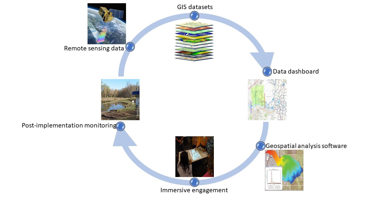
The use of Geographic Information Systems (GIS) and remote sensing technologies for the development of water quality management programs and for post-implementation assessments has increased dramatically in the past decade. This increase in adoption has been made more accessible through the interfaces of many popular software tools used in the regulation and assessment of water quality. Customized applications of these tools will increase, as ease of access and affordability of directly monitored and remotely sensed datasets improve over time. Concurrently, there is a need for inclusive participatory engagement with stakeholders to achieve solutions to current watershed management challenges. This paper explores the potential of these GIS and remote sensing datasets, tools, models, and immersive engagement technologies from other domains, for improving public participation and stakeholder engagement throughout the watershed planning process. To do so, an initial review is presented about the use of GIS and remote sensing in watershed management and its role in impairment identification, model development, and planning and implementation. Then, ways in which GIS and remote sensing can be integrated with stakeholder engagement through (1) leveraging GIS and remote sensing datasets, and (2) stakeholder engagement approaches including outreach and education, modeler-led development, and stakeholder-led involvement and feedback, are discussed. Finally, future perspectives on the potential for transforming public participation and stakeholder engagement in the watershed management process through applications of GIS and remote sensing are presented.
References
Adkins, T., & Monschein, E. (2009). Category 4b Demonstration for Point Source Impaired Waters and the Permit in Lieu of a Total Maximum Daily Load Process for the State of Missouri. 9p. Accessed May 3, 2022. Available at: https://www.epa.gov/sites/production/files/2015-10/documents/11b.pdf.
Ahmadisharaf, E., Lacher, I.L., Fergus, C., Benham, B.L., Akre, T. & Kline, K.S. (2020). Projecting land use change impacts on nutrients, sediment and runoff in multiple spatial scales: business-as-usual vs. stakeholder-informed scenarios. Journal of Cleaner Production, 257, 120466. https://doi.org/10.1016/j.jclepro.2020.120466.
Alamanos, A., Rolston, A., & Papaioannou, G. (2021). Development of a Decision Support System for Sustainable Environmental Management and Stakeholder Engagement. Hydrology, 8(1), 40. https://doi.org/10.3390/hydrology8010040.
American Society of Civil Engineers/Environmental and Water Resources Institute Total Maximum Daily Load Analysis and Modeling Task Committee (ASCE/EWRI TMDL-TC) (2017). Total maximum daily load analysis and modeling: Assessment of the practice. Reston, VA: ASCE. 167p. https://doi.org/10.1061/9780784414712.
American Society of Civil Engineers/Environmental and Water Resources Institute Total Maximum Daily Load Analysis and Modeling Task Committee (ASCE/EWRI TMDL-TC) (2022). Total maximum daily load analysis and modeling. Zhang, H.X., Quinn, N.W.T., Borah, D.K., Padmanabhan, G. (Editors). Reston, VA: ASCE. ASCE Manuals and Reports on Engineering Practice No. 150. 419p. https://doi.org/10.1061/9780784415948.
Anding, D., & Kauth, R. (1970). Estimation of sea surface temperature from space. Remote Sensing of the Environment, 1, 217–220. https://doi.org/10.1016/S0034-4257(70)80002-5.
Aquaveo (2017). Watershed Modeling System 10.1. Accessed May 2, 2022. Available at: http://www.aquaveo.com/software/wms-watershed-modeling-system-introduction.
Arnold, J.G., Moriasi, D.N., Gassman, P.W., Abbaspour, K.C., White, M.J., Srinivasa, R., Santhi, C., Harmel, R.D., Van Griensven, A., Van Liew, M.W., & Kannan, N. (2012). SWAT: Model use, calibration, and validation. Transactions of the ASABE, 55(4), 1491–1508. https://doi.org/10.13031/2013.42256.
Assaf, H., & Saadeh, M. (2008). Assessing water quality management options in the Upper Litani Basin, Lebanon, using an integrated GIS-based decision support system. Environmental Modelling and Software, 23(10-11), 1327-1337. https://doi.org/10.1016/j.envsoft.2008.03.006.
Balestrini, M., Kotsev, A., Ponti, M. & Schade, S. (2021). Collaboration matters: capacity building, up-scaling, spreading, and sustainability in citizen-generated data projects. Humanities and Social Sciences Communications, 8(169):1-15. https://doi.org/10.1057/s41599-021-00851-5.
Bardar, E. (2022). Why citizen science for water quality? NASA Terra. Accessed May 3, 2022. Available at: https://terra.nasa.gov/citizen-science/water-quality.
Barnes, A. P., Willock, J., Toma, L. & Hall, C. (2011). Utilising a farmer typology to understand farmer behaviour towards water quality management: Nitrate Vulnerable Zones in Scotland. Journal of Environmental Planning and Management, 54(4), 477-494. https://doi.org /10.1080/09640568.2010.515880
Bathke, D.J., Haigh, T., Bernadt, T., Wall, N., Hill, H. & Carson, A. (2019). Using serious games to facilitate collaborative water management planning under climate extremes. Journal of Contemporary Water Research and Education, 167(1), 50-67. https://doi.org/10.1111/j.1936-704X.2019.03311.x.
Bauer, P., & Bennartz, R. (1998). Tropical rainfall measuring mission microwave imaging capabilities for the observation of rain clouds. Radio Science, 33(2), 335-349. https://doi.org/10.1029/97RS02049.
Beamer, J., Huntington, J.L., Morton, C.G., & Pohll, G.M. (2013). Estimating annual Groundwater Evapotranspiration from Phreatophytes in the Great Basin using Landsat and Flux Tower measurements. Journal of the American Water Resources Association, 49(3), 518-533. https://doi.org/10.1111/jawr.12058.
Benham, B.L., Baffaut, C., Zeckoski, R.W., Mankin, K.R., Pachepsky, Y.A., Sadeghi, A.M., Brannan, K.M., Soupir M.L. & Habersack, M.J. (2006). Modeling bacteria fate and transport in watersheds to support TMDLs. Transactions of the ASABE, 49(4), 987-1002. https://doi.org/10.13031/2013.21739.
Bingner, R.L., Theurer, F.D., & Yuan, Y. (2003). AnnAGNPS Technical Processes. Accessed May 3, 2022. Available at: http://www.ars.usda. gov/Research/docs.htm?docid=5199.
Borah, D., & Bera, M. (2003). Watershed-scale hydrologic and nonpoint-source pollution models: review of mathematical bases. Transactions of the ASAE, 46(6), 1553-1566. https://doi.org/10.13031/2013.15644.
Borah, D.K., & Bera, M. (2004). Watershed-scale hydrologic and nonpoint-source pollution models: Review of applications. Transactions of the ASAE, 47(3), 789-803. https://doi.org/10.13031/2013.16110.
Borah, D.K., Yagow, G., Saleh, A., Barnes, P., Rosenthal, L.W., Krug, E.C, & Hauck, L.M. (2006). Sediment and Nutrient Modeling for TMDL Development and Implementation. Transactions of the ASABE, 49(4), 967-986. https://doi.org/10.13031/2013.21742.
Bresler, H., Mann, L., & Monschein, E. (2009). Category 4b Demonstration for Pathogen Impaired Tributaries to Puget Sound in Kitsap County, Washington. 9p. Accessed May 3, 2022. Available at: https://www.epa.gov/sites/production/ files/2015-10/documents/11d.pdf.
Bristol City Council (2019). Connecting Bristol: laying the foundations for a smart, well-connected future. 36p. Accessed May 3, 2022. Available at: https://www.connectingbristol.org/wp-content/uploads/2019/09/Connecting_Bristol_ 300819_WEB.pdf.
California Environmental Protection Agency (CalEPA) (2002). Total Maximum Daily Load for Salinity and Boron in the Lower San Joaquin River. Staff report. Sacramento, CA: Regional Water Quality Control Board, Central Valley Region. 105p. Accessed May 3, 2022. Available at: https://www.waterboards.ca.gov/rwqcb5/water_issues/tmdl/central_valley_ projects/vernalis_salt_boron/saltandborontmdljan2002.pdf.
Capdevila, A. S. L., Kokimova, A., Ray, S. S., Avellán, T., Kim, J., & Kirschke, S. (2020). Success factors for citizen science projects in water quality monitoring. Science of the Total Environment, 728, 137843. https://doi.org/10.1016/j.scitotenv.2020.137843.
Central Valley Regional Water Quality Control Board (CVRWQCB) (2004). Amendments to the Water Quality Control Plan for the Sacramento River and San Joaquin River Basin. Draft Final Staff Report and Technical TMDL Report, Sacramento, CA: State Water Resources Control Board, Central Valley Region. https://www.waterboards.ca.gov/rwqcb5/ water_issues/basin_plans/changes/.
Cho, S. J., Wilcock, P.R., Belmont, P., Gran, K.B., Hobbs, B.F. (2019). Simulation model for collaborative decision making on sediment source reduction in an intensively managed watershed. Water Resources Research, 55(2), 1544–1564. https://doi.org/10.1029/2018WR024324.
Choi, J.K., Min, J.-E., Noh, J.H., Han, T.-H., Yoon, S., Park, Y.J., Moon, J.-E., Ahn, J.-H., Ahn., S.M., & Park, J.-H. (2014). Harmful Algal Bloom (HAB) in the East Sea identified by the Geostationary Ocean Color Imager (GOCI). Harmful Algae, 39, 295-302. https://doi.org/10.1016/j.hal.2014.08.010.
Cook, M., Schott, J.R., Mandel, J., & Raqueno, N.( 2014). Development of an operational calibration methodology for the Landsat thermal data archive and initial testing of the atmospheric compensation component of a Land Surface Temperature Product from the archive. Remote Sensing, 6(11), 11244-11266. https://doi.org/10.1002/2015GL065564.
Criollo, R., Velasco, V., Nardi, A., De Vries, L. M., Riera, C., Scheiber, L., & Vázquez-Suñé, E. (2019). AkvaGIS: An open-source tool for water quantity and quality management. Computers and Geosciences, 127, 123-132. https://doi.org/10.1016/j.cageo.2018.10.012.
Crooke, B., McKinna, L.I.W., & Cetinić, I. (2017). From toes to top-of-atmosphere: Fowler’s Sneaker Depth index of water clarity for the Chesapeake Bay, Optics Express, 25(8), A361-A374. https://doi.org/10.1364/OE.25.00A361.
Daniels, M.E., Sridharan, V.K., Danner, E.M., & John, S.N. (2018). Calibration and validation of linked water temperature models for the Shasta Reservoir and the Sacramento River from 2000 to 2015. Santa Cruz, CA: NOAA Technical Memorandum No. NOAA-TM-NMFS-SWFSC 597. http://doi.org/10.7289/V5/TM-SWFSC-597.
DataShift. (2015). What is citizen-generated data and what is the DataShift doing to promote it? Accessed May 3, 2022. Available at: http://civicus.org/images/ER%20cgd_brief.pdf.
De Freitas, D.M., King, D., & Cottrell, A. (2013). Fits and misfits of linked public participation and spatial information in water quality management on the Great Barrier Reef coast, Australia. Journal of Coastal Conservation, 17, 253–269. https://doi.org/10.1007/s11852-011-0167-y.
Deutsch, E.S., Cardille, J.A., Koll-Egyed, T., & Fortin, M.J. (2021). Landsat 8 lake water clarity empirical algorithms: Large-scale calibration andvalidation using government and citizen science data from across Canada. Remote Sensing, 13(7), 1257. https://doi.org/10.3390/rs13071257.
Dhiman, R., VishnuRadhan, R., Inamdar, A.B., & Eldho, T.I. (2020). Web-GIS integrated open-source mashup technology as a cue for integrated management in coastal megacities. Journal of Coastal Conservation. 24(2), 1-12. https://doi.org/10.1007/s11852-020-00734-y.
Di Luzio, M., Srinivasan, R., & Arnold J.G. (2004). A GIS-Coupled Hydrological Model System for the Watershed Assessment of Agricultural Nonpoint and Point Sources of Pollution. Transactions in GIS, 8(1), 113-136. https://doi.org/10.1111/j.1467-9671.2004.00170.x.
Diaz, J.C.F., Carter W.E., Shrestha R.L., & Glennie, C.L. (2013). Lidar remote sensing. In Handbook of Satellite Applications. pp757-808.
Doherty, J. E., & Hunt, R.J. (2010). Approaches to highly parameterized inversion – a guide to using PEST for groundwater-model calibration. Scientific Investigations Report 2010–5169. Reston, VA: United States Geological Survey.
Duda, P., J. Kittle, Jr., M. Gray, P. Hummel, & Dusenbury, R. (2001). WinHSPF version 2.0: an interactive Windows interface to HSPF. User’s Manual. Washington, D.C.: U.S. Environmental Protection Agency.
Eakin, H., Bojórquez-Tapia, L.A., Janssen, M.A., Georgescu, M., Manuel-Navarrete, D., Vivoni, E.R., & Lerner, A.M. (2017). Opinion: urban resilience efforts must consider social and political forces. Proceedings of the National Academy of Sciences, 114(2), 186-189. https://doi.org/10.1073/pnas.1620081114.
Ehmann, K., Kelleher, C., & Condon, L.E. (2019). Monitoring turbidity from above: Deploying small unoccupied aerial vehicles to image in-stream turbidity. Hydrological Processes, 33(6), 1013–1021. https://doi.org/10.1002/hyp.13372.
Elliott, A.H., Semadeni-Davies, A.F., Shankar, U., Zeldis, J.R., Wheeler, D.M., Plew, D.R., Rys, G.J., & Harris, S.R. (2016). A national-scale GIS-based system for modelling impacts of land use on water quality. Environmental Modeling and Software, 86, 131–144. https://doi.org/10.1016/j.envsoft.2016.09.011.
Epstein, R., Patai, E., Julian, J. & Spiers, H.J. (2017). The cognitive map in humans: spatial navigation and beyond. Nature Neuroscience, 20:1504–1513. https://doi.org/10.1038/nn.4656.
Estalaki, S.M., Kerachian, R., & Nikoo, M.R. (2016). Developing water quality management policies for the Chitgar urban lake: application of fuzzy social choice and evidential reasoning methods. Environmental Earth Sciences, 75(5), 404. 10.1007/s12665-015-5065-4.
Ferrari, G.M., Dowell, M.D., Grossi, S., & Targa, C. (1996). Relationship between the optical properties of chromophoric dissolved organic matter and total concentration of dissolved organic carbon in the Southern Baltic Sea region. Marine Chemistry, 55, 299–316. https://doi.org/10.1016/S0304-4203(96)00061-8.
Fink, G., Burke, S., Simis, S.G., Kangur, K., Kutser, T., & Mulligan, M. (2020). Management options to improve water quality in Lake Peipsi: insights from large scale models and remote sensing. Water Resources Management, 34(7), 2241-2254. https://doi.org/10.1007/s11269-018-2156-5.
Fisher, J.R.B., Acosta, E.A., Dennedy‐Frank, P.J., Kroeger, T., & Boucher, T.M. (2018). Impact of satellite imagery spatial resolution on land use classification accuracy and modeled water quality. Remote Sensing in Ecology and Conservation, 4(2), 137–149. https://doi.org/10.1002/rse2.61.
Flood, S., Cradock-Henry, N.A., Blackett, P., & Edwards, P. (2018). Adaptive and interactive climate futures: systematic review of ‘serious games’ for engagement and decision-making. Environmental Research Letters, 13(6), 063005. https://doi.org/10.1088/1748-9326/aac1c6.
Flynn, T., Stiles. T., Perkins B., & Monschein, E. (2009). Category 4b Demonstration for Atrazine Impaired Waters in the Little Arkansas River Subbasin. 15p. Accessed May 3, 2022. Available at: https://www.epa.gov/sites/production/files/2015-10/documents/11e.pdf.
Franks, D.M., Davis, R., Bebbington, A.J., Ali, S.H., Kemp, D., & Scurrah, M. (2014). Conflict translates environmental and social risk into business costs. Proceedings of the National Academy of Sciences, 111(21), 7576-7581. https://doi.org/10.1073/pnas.1405135111.
Ganjali, N., & Guney, C. (2017). GIS and game theory for water resource management. ISPRS Annals of the Photogrammetry. Remote Sensing and Spatial Information Sciences, 4, 215-220. 10.5194/isprs-annals-IV-4-W4-215-2017.
Gassman, P.W., Willians, J.R., Wang, X., Saleh, A., Osei, E., Hauck, L.M., Izaurralde, C., & Flowers, J.D. (2009). The Agricultural Policy Environmental EXtender (APEX) Model: an emerging tool for landscape and watershed environmental analyses. Technical Report 09-TR 49. Center for Agricultural and Rural Development. Ames, IA: Iowa State University. 111p. Available at: https://www.card.iastate.edu/products/publications/pdf/09tr49.pdf.
George, G., Menon, N. N., Abdulaziz, A., Brewin, R. J. W., Pranav, P., Gopalakrishnan, A., Mini, K. G., Kuriakose, S., Sathyendranath, S., & Platt, T. (2021). Citizen Scientists Contribute to Real-Time Monitoring of Lake Water Quality Using 3D Printed Mini Secchi Disks. Frontiers in Water, 3. https://doi.org/10.3389/frwa.2021.662142.
Gholizadeh, M.H., Melesse, A.M., and Reddi, L. (2016). A Comprehensive Review on Water Quality Parameters Estimation Using Remote Sensing Technologies. Sensors, 16(8), 1298. https://doi.org/10.3390/s16081298.
Giardino, C., Bresciani, M., Villa, P., & Martinelli, A. (2010). Application of remote sensing in water resource management: the case study of Lake Trasimeno, Italy. Water Resources Management, 24(14), 3885-3899. https://doi.org/10.1007/s11269-010-9639-3.
Graham, D.N., & Butts, M.B. (2005). Flexible, integrated watershed modelling with MIKE SHE. In Watershed Models, V.P. Singh, V.P. & Frevert, D.K. Editors. pp 245-272, CRC Press. ISBN: 0849336090.
Guimarães, T.T., Veronez, M.R., Koste, E.C., Souza, E.M., Brum, D., Gonzaga, L., & Mauad, F.F. (2019). Evaluation of regression analysis and neural networks to predict total suspended solids in water bodies from unmanned aerial vehicle images. Sustainability (Switzerland), 11(9). https://doi.org/10.3390/su11092580.
Habermann, C., & Ward, R.C. (2001). Comparing Water Quality Moitoring Requirements in European and United States Laws. In Proceedings of Monitoring Tailor-Made III, Nunspect, The Netherlands.
Hadj-Hammou, J., Loiselle, S., Ophof, D., & Thornhill, I. (2017). Getting the full picture: Assessing the complementarity of citizen science and agency monitoring data. PLoS One, 12(12), e0188507. https://doi.org/10.1371/journal.pone.0188507.
Haith, D.A., Mandel, R. & Wu, R.S. (1992). Generalized watershed loading functions version 2.0. user’s manual. Ithaca, NY: Dept. of Agricultural and Biological Engineering, Cornell University. Accessed May 3, 2022. Available at: https://owl.cwp.org/mdocs-posts/generalized-watershed-loading-functions-version-2-0-users-manual/.
Hall, B.M. (2016). Lack of inclusive stakeholder representation in watershed management groups in the midwest: A threat to legitimacy. Geography Bulletin, 57, 77–97.
Handcock, R., Gillespie, A., Cherkauer, K., Kay, J., Burges, S., & Kampf, S. (2006). Accuracy and uncertainty of thermal-infrared remote sensing of stream temperatures at multiple spatial scales. Remote Sens. Environ. 100, 427–440.
Hansen, M.C., Potapov, P.V., Moore, R., Hancher, M., Turubanova, S.A., Tyukavina, A., Thau, D., Stehman, S.V., Goetz, S.J., Loveland, T.R. & Kommareddy, A.,(2013). High-resolution global maps of 21st-century forest cover change. Science, 342(6160), 850-853. 10.1126/science.1244693.
Hantush, M.M. (2005). Modeling stream–aquifer interactions with linear response functions. Journal of Hydrology, 311(1-4), 59-79. https://doi.org/10.1016/j.jhydrol.2005.01.007.
Harris, M.J., Stinson, J., & Landis, W.G. (2017). A Bayesian Approach to Integrated Ecological and Human Health Risk Assessment for the South River, Virginia Mercury-Contaminated Site. Risk Analysis, 37(7), 1341–1357. https://doi.org/10.1111/risa.12691.
HAWQS (2020). "HAWQS System and Data to model the lower 48 conterminous U.S using the SWAT model", doi.org/10.18738/T8/XN3TE0, Texas Data Repository Dataverse, V1.
Herr, J.W., & Chen, C.W. (2012). WARMF: Model use, calibration, and validation. Transactions of the ASABE, 55(4), 1387–1396. https://doi.org/10.13031 /2013.42249.
Hoffman, G.J. (2010). Salt Tolerance of Crops in the Southern Sacramento‐San Joaquin Delta. Prepared on Behalf of the California Environmental Protection Agency, State Water Resources Control Board, Division of Water Rights. Final Report. Accessed May 3, 2022. Available at: http://www.swrcb.ca.gov/waterrights/water_issues/programs/ bay_delta/bay_delta_plan/water_quality_control_planning/docs/final_study_report.pdf.
Hulley, G.C., & Hook, S. (2011). Generating Consistent Land Surface Temperature and Emissivity Products Between ASTER and MODIS Data for Earth Science Research. IEEE Transactions on Geoscience and Remote Sensing, 49, 1304-1315. https://doi.org/ 10.1109/TGRS.2010.2063034.
Ines, A.V., Honda, K., Gupta, A.D., Droogers, P., & Clemente, R.S. (2006). Combining remote sensing-simulation modeling and genetic algorithm optimization to explore water management options in irrigated agriculture. Agricultural water management, 83(3), 221-232. https://doi.org/10.1016/j.agwat.2005.12.006.
Innovyze (2017). InfoSWMM. Accessed May 3, 2022. Available at: http://www.innovyze.com/products/infoswmm/.
Japan Association of Remote Sensing (JARS) (1996). Microwave altimeter. Accessed May 3, 2022. Available at: http://sar.kangwon.ac.kr/etc/rs_note/rsnote/cp4/cp4-10.htm.
Jean, S., Medema, W., Adamowski, J., Chew, C., Delaney, P., & Wals, A. (2018). Serious games as a catalyst for boundary crossing, collaboration, and knowledge co-creation in a watershed governance context. Journal of Environmental Management, 223, 1010-1022. https://doi.org/10.1016/j.jenvman.2018.05.021.
Jiang, D., & Wang, K. (2019). The role of satellite-based remote sensing in improving simulated streamflow: A review. Water, 11(8), 1615. https://doi.org/10.3390/w11081615.
Johnson, B. A., & Iizuka, K. (2016). Integrating OpenStreetMap crowdsourced data and Landsat time-series imagery for rapid land use/land cover (LULC) mapping: Case study of the Laguna de Bay area of the Philippines. Applied Geography, 67, 140-149. https://doi.org/10.1016/j.apgeog.2015.12.006.
Kang, M.S. (2002). Development of total maximum daily loads simulation system using artificial neural networks for satellite data analysis and nonpoint source pollution models. Ph.D. Thesis, Seoul, Korea: Seoul National University (in Korean).
Kang, M.S., & Park, S.W. (2003). Development and application of total maximum daily loads simulation system using nonpoint source pollution model. Journal of the Korea Water Resources Association. 36(1), 117–128. https://doi.org/10.3741/JKWRA.2003.36.1.117.
Karpouzli, E., & Malthus, T. (2003). The empirical line method for the atmospheric correction of IKONOS imagery. International Journal of Remote Sensing, 24(5), 1143-1150. https://doi.org/10.1080/0143116021000026779.
Kirschbaum, D. B., Huffman, G. J., Adler, R. F., Braun, S., Garrett, K., Jones, E., McNally, A., Skofronick-Jackson, G., Stocker, E., Wu, H., & Zaitchik, B.F. (2017).. NASA’s remotely sensed precipitation: A reservoir for applications users. Bulletin of the American Meteorological Society, 98(6), 1169-1184.
Kislik, C., Dronova, I., & Kelly, M. (2018). UAVs in Support of Algal Bloom Research: A Review of Current Applications and Future Opportunities. Drones, 2(4), 35. https://doi.org/10.3390/drones2040035.
Korfmacher, K.S. (2001). The Politics of Participation in Watershed Modeling. Environmental Management, 27(2), 161–176. https://doi.org/10.1007/s002670010141.
Kudela, R.M., Palacios, S.L., Austerberry, D.C., Accorsi, E.K., Guild, L.S., & Torres-Perez, J. (2015). Application of hyperspectral remote sensing to cyanobacterial blooms in inland waters. Remote Sensing of the Environment, 167, 196-205. https://doi.org/10.1016/j.rse.2015.01.025.
Kudryavtsev, V., Myasoedov, A., Chapron, B., Johannessen, J.A., & Collard, F. (2012). Imaging mesoscale upper ocean dynamics using synthetic aperture radar and optical data. Journal of Geophysical Research: Oceans, 117, C04029. https://doi.org/10.1029/2011JC007492.
Kuenzer, C., Ottinger, M., Wegmann, M., Guo, H., Wang, C., Zhang, J., Dech, S., & Wikelski, M. (2014). Earth observation satellite sensors for biodiversity monitoring: potentials and bottlenecks. International Journal of Remote Sensing, 35(18), 6599-6647. https://doi.org/10.1080/01431161.2014.964349
Little, S., Pavelsky, T.M., Hossain, F., Ghafoor, S., Parkins, G. M., Yelton, S. K., Rodgers, M., Yang, X., Crétaux, J. F., Hein, C., Ullah, M. A., Lina, D. H., Thiede, H., Kelly, D., Wilson, D., & Topp, S.N. (2021). Monitoring variations in lake water storage with satellite imagery and citizen science. Water, 13(7), 949. https://doi.org/10.3390/w13070949.
Maccani, G., Goossensen, M., Righi, V., Creus, D J., & Balestrini, M. (2020). Scaling up citizen science: what are the factors associated with increased reach and how to lever them to achieve impact. JRC: Ispra (VA), Italy.
Maggioni, V., & Massari, C. (2018). On the performance of satellite precipitation products in riverine flood modeling: A review. Journal of Hydrology, 558, 214-224.
Malthus, T. J., Ohmsen, R., & van der Woerd, H.J. (2020). An evaluation of citizen science smartphone apps for Inland water quality assessment. Remote Sensing, 12(10), 1578. https://doi.org/10.3390/rs12101578.
Martin, P., LeBoeuf, E., Dobbins, J., Daniel, E., & Abkowitz, M. (2005). Interfacing GIS with Water Resource Models: A State-of-the-Art Review. Journal of the American Water Resources Association, 41(6), 1471-1487. https://doi.org/10.1111/j.1752-1688.2005.tb03813.x.
Mayer, A., Heyman, J., Granados-Olivas, A., Hargrove, W., Sanderson, M., Martinez, E., & Alatorre-Cejudo, L.C. (2001). Investigating Management of Transboundary Waters through Cooperation: A Serious Games Case Study of the Hueco Bolson Aquifer in Chihuahua, Mexico and Texas, United States. Water, 13(15), 2001. https://doi.org/10.3390/w13152001.
McCabe, M.F., Rodell, M., Alsdorf, D.E, Miralles, D.G., Uijlenhoet, R., Wagner, W., Lucieer, A., Houborg, R., Verhoest, N.E.C., Franz, T.E., Shi, J., Gao, H., & Wood, E.F. (2017). The Future of Earth Observation in Hydrology, Hydrology and Earth System Sciences, https://doi.org/10.5194/hess-2017-54.
McDonald, W. (2019). Drones in urban stormwater management: a review and future perspectives. Urban Water Journal, 16(7), 505–518. https://doi.org/10.1080/1573062X.2019.1687745.
Medema, W., Furber, A., Adamowski, J., Zhou, Q., & Mayer, I. (2016). Exploring the potential impact of serious games on social learning and stakeholder collaborations for transboundary watershed management of the St. Lawrence River Basin. Water, 8(5), 175. https://doi.org/10.3390/w8050175.
Medema, W., Mayer, I., Adamowski, J., Wals, A.E., & Chew, C. (2019). The potential of serious games to solve water problems: editorial to the special issue on game-based approaches to sustainable water governance. Water, 11(12), 2562. https://doi.org/10.3390/w11122562.
Menon, N., George, G., Ranith, R., Sajin, V., Murali, S., Abdulaziz, A., Brewin, R.J.W., & Sathyendranath, S. (2021). Citizen science tools reveal changes in estuarine water quality following demolition of buildings. Remote Sensing, 13(9), 1–12. https://doi.org/10.3390/rs13091683.
Mohajane, M., Essahlaoui, A., Oudija, F., Hafyani, M.E., Hmaidi, A.E., Ouali, A.E., Randazzo, G., & Teodoro, A.C. (2018). Land use/land cover (LULC) using landsat data series (MSS, TM, ETM+ and OLI) in Azrou Forest, in the Central Middle Atlas of Morocco. Environments, 5(12), 131. https://doi.org/10.3390/environments5120131.
Monschein, E., & Reems, S. (2009). Category 4b – current national status and trends. 24p. Accessed May 3, 2022. Available at: https://www.epa.gov/sites/production/files/2015-10/documents/11a.pdf.
Naikoo, M. W., Rihan, M., & Ishtiaque, M. (2020). Analyses of land use land cover (LULC) change and built-up expansion in the suburb of a metropolitan city: Spatio-temporal analysis of Delhi NCR using landsat datasets. Journal of Urban Management, 9(3), 347-359. https://doi.org/10.1016/j.jum.2020.05.004.
National Aeronautics and Space Administration (NASA). (2022). Commercial Smallsat Data Acquisition Program. Accessed May 3, 2022. Available at: https://csdap.earthdata.nasa.gov/.
National Oceanic and Atmospheric Administration. (2022). National Ocean Service. Accessed May 2, 2022. Avaliable at http://oceanservice.noaa.gov/facts/nutrient-pollution.jpg.
Neitsch, S. L., Arnold, J. G., Kiniry, J. R., & Williams, J. R. (2011). Soil and water assessment tool theoretical documentation version 2009. Texas Water Resources Institute.
New York State Department of Environmental Conservation (NYSDEC). (2021). Clean water plans. Accessed May 3, 2022. Available at: https://www.dec.ny.gov/chemical/23835.html.
North Carolina Department of Environmental Quality (NCDEQ). (2021). TMDL alternative. Accessed May 3, 2022. Available at: https://deq.nc.gov/about/divisions/water-resources/planning/modeling-assessment/tmdl-alternative.
Nunoo, R., Anderson, P., Kumar, S., & Zhu, J. (2020). Margin of safety in TMDLs: natural language processing-aided review of the state of practice. Journal of Hydrologic Engineering, 25, 404020002. https://doi.org/10.1061/(ASCE)HE.1943-5584.0001889
Olmanson L.G., Brezonik P.L., & Bauer M.E., (2013). Airborne hyperspectral remote sensing to assess spatial distribution of water quality characteristics in large rivers: The Mississippi River and its tributaries in Minnesota. Remote Sensing of Environment. 130, 254-265. https://doi.org/10.1016/j.rse.2012.11.023.
Owojori, A., & Xie, H. (2005). Landsat image-based LULC changes of San Antonio, Texas using advanced atmospheric correction and object-oriented image analysis approaches. In 5th international symposium on remote sensing of urban areas, Tempe, AZ.
Pekel, J.F., Cottam, A., Gorelick N.,& Belward, A.S. (2016). High-resolution mapping of global surface water and its long-term changes. Nature, 540, 418-422. https: doi:10.1038/nature20584.
Petherick, A. (2014). Adaptation with participation. Nature Climate Change, 4(8), 660-661. https://doi.org/10.1038/nclimate2324.
Ponce-Romero, J. M., Hallett, S. H.,& Jude, S. (2017). Leveraging big data tools and technologies: Addressing the challenges of the water quality sector. Sustainability, 9(12), 2160. https://doi.org/10.3390/su9122160.
Quinlivan, L., Chapman, D. V., & Sullivan, T. (2020). Validating citizen science monitoring of ambient water quality for the United Nations sustainable development goals. Science of the Total Environment, 699, 134255. https://doi.org/10.1016/j.scitotenv.2019.134255.
Quinn, N.W.T. (2020), Policy innovation and governance for irrigation sustainability in the arid, saline San Joaquin River Basin. Sustainability. 12(11), 4733. https://doi.org/10.3390/su12114733.
Quinn, N.W.T., Hughes, B., Osti, A., Herr, & J. Wang, J. (2018). Real-time, web-based decision support for stakeholder implementation of basin-scale salinity management. IFIP AICT 507 keynote in: Environmental Software Systems, Computer Science for Environmental Protection, ISESS 2017, J. Hrebicek, R. Denzer, G. Schimak and T.Pitner, Editors. Croatia, May 10-12, 2017. Springer.
Quinn, N.W.T., Kumar, S., & Imen, S. (2019). Overview of remote sensing and GIS uses in watershed and TMDL analyses. Journal of Hydrologic Engineering, 24(4). https://doi.org/10.1061/(ASCE)HE.1943-5584.0001742.
Quinn, N.W.T., Kumar, S., Imen, S., & Sridharan, V.K. (2022). Model Data, Geographical Information Systems, and Remote Sensing. In Harry et al. (Eds.), Total Maximum Daily Load Development and Implementation: Models, Methods, and Resources. ASCE. https://ascelibrary.org/doi/book/10.1061/9780784415948.
Quinn, N.W.T., & Oster, J.D. (2021). Innovations in Sustainable Groundwater and Salinity Management in California’s San Joaquin Valley. Sustainability, 13(12):6658. https://doi.org/10.3390/su13126658.
Ramirez, C.M., Viers, J.H., Quinn, J.F, Johnson M.L., Kozlowicz, B., & Florsheim, J. (2005). Mass wasting identification in the Navarro River Watershed using hyperspectral imagery. California and the World Ocean ’02, 1279–1288. American Society of Civil Engineers, Reston, VA.
Ramirez-Avila, J.J., Radcliffe, D.E., Osmond, D., Bolster, C., Sharpley, A., Ortega-Achury, S.L., Forsberg, A. & Oldham, J.L. (2017). Evaluation of the APEX model to simulate runoff quality from agricultural fields in the Southern Region of the United States. Journal of Environmental Quality, 46, 1357-1364. https://doi.org/10.2134/jeq2017.07.0258.
Ross, M.R.V., Topp, S.N., Appling, A.P., Yang, X., Kuhn, C., Butman, D., Simard, M. & Tamlin M. Pavelsky, T.M. (2019). AquaSat: A data set to enable remote sensing of water quality for inland waters. Water Resources Research, 55(11), 10012-10025. https://doi.org/10.1029/2019WR024883.
Sayers, M., Grimm, A., Shuchman, R., Deines, A., Bunnell, D.F., Raymer, Z.B, Rogers, M.W., Woelmer, W., Bennion, D.H., Brooks, C.N., Whitley, M., Warner, D.M., & Mycheck-Londer, J. (2015). A new method to generate a high-resolution global distribution map of lake chlorophyll. International Journal of Remote Sensing, 36(7), 1942-1964. https://doi.org/10.1080/01431161.2015.1029099.
Sayles, J.S., & Baggio, J.A. (2017). Social–ecological network analysis of scale mismatches in estuary watershed restoration. Proceedings of the National Academy of Sciences, 114(10), E1776-E1785. https://doi.org/10.1073/pnas.1604405114.
Schaeffer B.A., Hagy J.D., Conmy R.N., Lehrter J.C., & Stumpf R.F. (2012). An approach to developing numeric water quality criteria for coastal waters using the SeaWiFS satellite data record. Environmental Science and Technology, 46(2), 916-922. https://doi.org/10.1021/es2014105.
Semadeni-Davies, A., Elliot, S., & Shankar, U. (2016) CLUES - Catchment Land Use for Environmental Sustainability User Manual Fifth Edition: CLUES 10.3, NIWA internal report: AKL2016-017.
Semadeni-Davies, A., Jones-Todd, C., Srinivasan, M. S., Muirhead, R., Elliott, A., Shankar, U., & Tanner, C. (2020). CLUES model calibration and its implications for estimating contaminant attenuation. Agricultural Water Management, 228, 105853. https://doi.org/https://doi.org/10.1016/j.agwat.2019.105853.
Seyhan, E., & Dekker, A. (1986). Application of remote sensing techniques for water quality monitoring. Hydrobiological Bulletin, 20, 41–50. https://doi.org/10.1007/BF02291149.
Shafique, N., Fulk F., & Autrey B.(2003). Hyperspectral remote sensing of water quality parameters for large rivers in the Ohio River basin. In Proceedings of the 1st Interagency Conference on Research in the Watersheds, Benson, AZ.
Sibanda, M., Mutanga, O., Chimonyo, V.G., Clulow, A.D., Shoko, C., Mazvimavi, D., Dube, T., & Mabhaudhi, T. (2021). Application of drone technologies in surface water resources monitoring and assessment: a systematic review of progress, challenges, and opportunities in the global south. Drones, 5(3), 84. https://doi.org/10.3390/drones5030084.
Smith, D., Li, J., & Banting, D. (2005). A PCSWMM/GIS-based water balance model for the Reesor Creek watershed. Atmospheric Research, 77(1-4), 388-406. https://doi.org/10.1016/j.atmosres.2004.12.010.
Sneddon, C., Barraud, R., & Germaine, M. A. (2017). Dam removals and river restoration in international perspective. Water Alternatives, 10(3), 648.
Soutter, M., Alexandrescu, M., Schenk, C., & Drobot, R. (2008). Adapting a geographical information system-based water resource management to the needs of the Romanian water authorities. Environmental Science and Pollution Research, 16(1), 33-41. 10.1007/s11356-008-0065-5.
Srinivas, R., Drewitz, M., & Magner, J. (2020). Evaluating watershed-based optimized decision support framework for conservation practice placement in Plum Creek Minnesota. Journal of Hydrology, 583, 124573. https://doi.org/10.1016/j.jhydrol.2020.124573.
Stevens, T., Gilder, C., & Walsh, D. (2009). Category 4b demonstration for petroleum hydrocarbon impaired waters in the Kenai River, Alaska, 10p. Accessed May 3, 2022. Available at: https://www.epa.gov/sites/production/files/2015-10/documents/11c.pdf.
Stewart, J., Baginski, T., Greene, G., Smith, A., & Sicherman, A. (2008). Spatial and quantitative approach to incorporating stakeholder values into total maximum daily loads: Dominguez channel case study. Journal of Map and Geography Libraries, 4, 296–307. https://doi.org/10.1080/15420350802142587.
Sun, A.Y., Miranda, R.M. & Xu, X. (2015). Development of multi-metamodels to support surface water quality management and decision making. Environmental and Earth Science, 73, 423–434. https://doi.org/10.1007/s12665-014-3448-6.
Swick, H. (2007). GIS and Stakeholder Involvement: A Customized Watershed Planning Process. Accessed May 3, 2022. Available at: https://tamug-ir.tdl.org/handle/1969.3/18642.
Teet, S., Nelson, A.N., Verser, J.A., Moriasi, D.N., Steiner, J.L., Starks, P.J., & Gowda, P.H. (2021). An In-house Manual for Building APEX Projects Using ArcAPEX. El Reno, OK: USDA ARS Grazinglands Research Laboratory.
Texas Commission on Environmental Quality (TCEQ). (2021). Watershed protection plans for nonpoint source water pollution. Accessed May 2, 2022. Available at: https://www.tceq.texas.gov/waterquality/nonpoint-source/mgmt-plan/watershed-pp.html.
United States Environmental Protection Agency (USEPA). (2010). Chesapeake Bay total maximum daily load for nitrogen, phosphorous and sediment. 93p. Accessed May 3, 2022. https://www.epa.gov/chesapeake-bay-tmdl/chesapeake-bay-tmdl-document.
United States Environmental Protection Agency (USEPA). (2013). A quick guide to developing watershed plans to restore and protect our waters. EPA Report No. 841-R-13-003. Office of Wetlands, Oceans, and Watersheds, Nonpoint Source Control Branch, Washington, DC. 39p. Accessed May 3, 2022. Available at: https://www.epa.gov/sites/default/files/2015-12/documents/watershed_mgmnt_quick_guide.pdf.
United States Environmental Protection Agency (USEPA). (2016a). Great Lakes Pollution Prevention and Toxics Reduction. Accessed May 3, 2022. Available at: https://archive.epa.gov/greatlakes/p2/web/html/introduction.html.
United States Environmental Protection Agency (USEPA). (2016b). Loading simulation program C. Accessed May 3, 2022. https://catalog.data.gov/dataset/loading-simulation-program-c.
United States Environmental Protection Agency (USEPA). (2017). Impaired waters and TMDLs. Accessed May 3, 2022. Available at: https://www.epa.gov/tmdl/tmdl-support-documents.
United States Environmental Protection Agency (USEPA). (2019). Better assessment science integrating point and nonpoint sources BASINS version 4.5 user’s manual. Washington, DC: Office of Water. 780p. Accessed May 3, 2022. Available at: https://www.epa.gov/system/files/documents/2022-02/basins4.5coremanual.2019.03_partial_508c.pdf.
United States Environmental Protection Agency (USEPA). (2020). Handbook for Developing Watershed Plans to Restore and Protect Our Waters. Accessed May 3, 2022. Available at: https://www.epa.gov/nps/handbook-developing-watershed-plans-restore-and-protect-our-waters.
United States Environmental Protection Agency (USEPA). (2021a). Border 2025: United States – Mexico environmental Program. EPA-906-B-21-001. 34p. Accessed May 3, 2022. Available at: https://www.epa.gov/sites/default/files/2021-05/documents/final_us_mx_border_2025_final_may_6.pdf.
United States Environmental Protection Agency (USEPA). (2021b). Cyanobacteria Assessment Network (CyAN). Accessed May 3, 2022. Available at: https://www.epa.gov/water-research/cyanobacteria-assessment-network-cyan.
United States Environmental Protection Agency (USEPA). (2022). Aerial river pollution image. Accessed May 2, 2022. https://www.epa.gov/sites/default/files/nutrientpollution/images/aerial_riverpollution.jpg.
United States Geological Survey. (2022). GWWebFlow. Accessed May 3, 2022. Available at: https://webapps.usgs.gov/gwwebflow/.
Vaneeckhaute, C., Walling, E., Rivest, S. Belia, E., Chartrand, I., Fortin, F., & Abolfazl, M. (2021). Towards an integrated decision-support system for sustainable organic waste management (optim-O). NPJ Urban Sustainability. 1, 27. https://doi.org/10.1038/s42949-021-00033-x.
Vargo, G. A. (2009). A brief summary of the physiology and ecology of Karenia brevis Davis (G. Hansen and Moestrup comb. nov.) red tides on the West Florida Shelf and of hypotheses posed for their initiation, growth, maintenance, and termination. Harmful Algae, 8(4), 573-584. https://doi.org/10.1016/j.hal.2008.11.002.
Venkatachalam, L. (2008). Behavioral economics for environmental policy. Ecological economics, 67(4), 640-645. https://doi-org.oca.ucsc.edu/10.1016/j.ecolecon.2008.01.018.
Viers, J.H., Ramirez, C.M., Quinn, J.F., & Johnson M.L. (2005). The use of hyperspectral technologies to identify riparian habitats in coastal watersheds: an example from the Navarro River, California. California and the World Ocean ’02, 1377–1391. American Society of Civil Engineers, Reston, VA.
Voinov, A., Jenni, K., Gray, S., Kolagani, N., Glynn, P. D., Bommel, P., & Smajgl, A. (2018). Tools and methods in participatory modeling: Selecting the right tool for the job. Environmental Modelling and Software, 109, 232-255. https://doi.org/10.1016/j.envsoft.2018.08.028.
Wang, T., B. Du, B. & Zhang, L. (2013). A kernel-based target-constrained interference-minimized filter for hyperspectral sub-pixel target detection, IEEE Journal of Selected Topics in Applied Earth Observations and Remote Sensing, 6(2), 626-637, 10.1109/JSTARS.2013.2251863.
Walker, W.W. (1997). GISPLM – A GIS-based phosphorus loading model applied to LaPlatte River, Vermont. Prepared for Vermont Department of Environmental Conservation by College of Charleston, Stone Environmental and W.W. Walker.
Wallace, C.W., Benham, B.L., Yagow, E.R., & Gallagher, D.L. (2018). Comparison of two alternative methods for developing TMDLs to address sediment impairments. Journal of Hydrologic Engineering, 23(12), 05018023. https://doi.org/10.1061/(ASCE)HE.1943-5584.0001728.
Wardropper, C.B., Chang, C., & Rissman, A.R. (2015). Fragmented water quality governance: constraints to spatial targeting for nutrient reduction in a Midwestern USA watershed. Landscape and Urban Planning, 137, 64-75. https://doi.org/10.1016/j.landurbplan.2014.12.011. https://doi.org/10.1016/j.landurbplan.2014.12.011.
Weingart, P., & Meyer, C. (2021). Citizen science in South Africa: Rhetoric and reality. Public Understanding of Science, 30(5), 605-620. https://doi.org/10.1177/0963662521996556.
Wickham, J.D., Homer, C.G., Vogelmann, J.E., McKerrow, A., Mueller, R., Herold, N.D., Coulston, J., (2014). The Multi-Resolution Land Characteristics (MRLC) Consortium—20 years of development and integration of USA national land cover data. Remote Sensing, 6(8), 7424–7441. https://doi.org/10.3390/rs6087424.
Winchell, M., Srinivasan, R., Di Luzio, M., & Arnold, J. (2007). ArcSWAT interface for SWAT 2005. User’sGuide, Temple, TX: Blackland Research Center, Texas Agricultural Experiment Station.
World Bank. (2022). Measuring precipitation: on the ground and from space. Accessed May 3, 2022. Available at: https://olc.worldbank.org/sites/default/files/sco/E7B1C4DE-C187-5EDB-3EF2-897802DEA3BF/Nasa/chapter2.html.
Wu, W. & Vieria, D.A. (2002). One-dimensional channel network model CCHE1D 3.0 -- technical manual. Technical Report No. NCCHE-TR-2002-1, National Center for Computational Hydroscience and Engineering, The University of Mississippi.
Xian, G., C. Homer, J. Dewitz, J. Fry, N. Hossain, & J. Wickham, (2011). Change of impervious surface area between 2001 and 2006 in the conterminous United States. Photogrammetry Engingeering and Remote Sensing, 77, 758–762.
Young, R.A., Onstad, C.A., Bosch, D.D., & Anderson, W.P. (1994). Agricultural non-point source pollution model. AGNPS User’s Guide, Version, 4. Accessed May 3, 2022. Available at: https://pubs.er.usgs.gov/publication/ofr2003130.
Yusuf, J. E., Rawat, P., Considine, C., Covi, M., St John, B., Nicula, J. G., & Anuar, K. A. (2018). Participatory GIS as a tool for stakeholder engagement in building resilience to sea level rise: a demonstration project. Marine Technology Society Journal, 52(2), 45-55. https://doi.org/10.4031/MTSJ.52.2.12.
Zaidi, A. (2012). Water Quality Management Using GIS and RS Tools. World Environmental and Water Resources Congress. 842-848.
Zhang, H.X., & Quinn N.W.T. (2019). Simple models and analytical procedures for total maximum daily load assessment. Journal of Hydrologic Engineering, 24(2), 02518002. https://doi.org/10.1061/(ASCE)HE.1943-5584.0001736.
Zhao, G., & Gao H., (2018). Automatic correction of contaminated images for assessment of reservoir surface area dynamics. Geophysical Research Letters, 45, 6092-6099. https://doi.org/10.1029/2018GL078343.

This work is licensed under a Creative Commons Attribution-NonCommercial 4.0 International License.
Copyright (c) 2022 Nigel Quinn, Vamsi Sridharan, John Ramirez-Avila , Sanaz Imen, Huilin Gao, Rocky Talchabhadel, Saurav Kumar, Walter McDonald